Sudan Ethiopia brotherhood
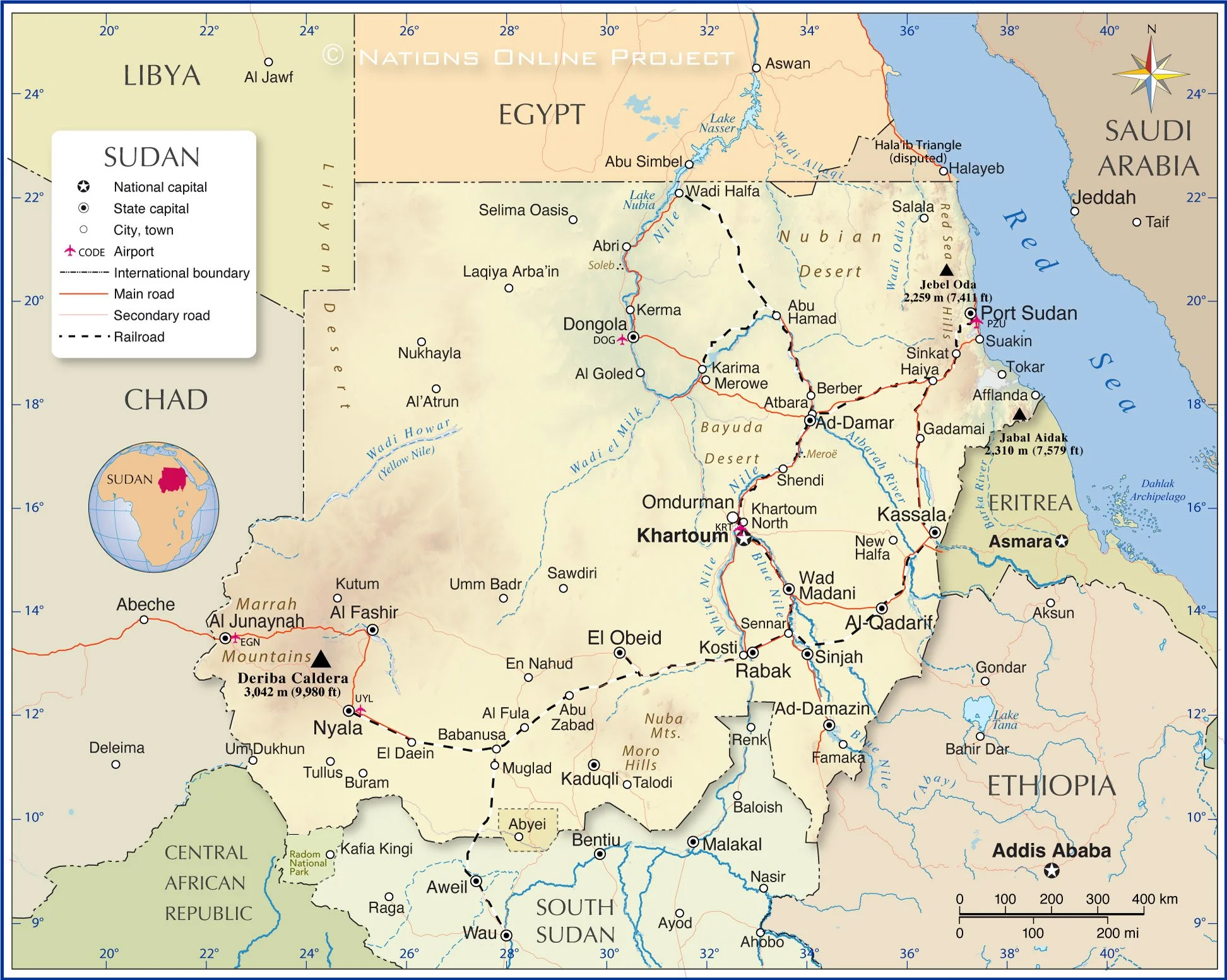
The map shows Sudan and surrounding countries with international borders, the national capital Khartoum, state capitals, major cities, main roads, railroads, and major airports.
You are free to use the above map for educational and similar purposes; if you publish it online or in print, you need to credit the Nations Online Project as the source.
More about Sudan
Fishing boats in the Red Sea, the Red Sea Hills in the background.
Photo: Mohammed
Sudan gained independence from British and Egyptian colonial rule in 1956.
In July 2011, Sudan was divided into two countries after the people of the south voted for independence. South Sudan became an independent state on 9th July 2011.
The division was a result of a long-standing conflict between the north and south of Sudan.
The conflict was mainly due to differences in religion, ethnicity, and political power. In the north, the population is predominantly Muslim and Arab, while in the south, people are predominantly of African descent and Christian. The division led to the displacement of millions of people and caused a humanitarian crisis.
Geography of Sudan
Sudan is one of the most geographically diverse countries in Africa. Its landscape includes the Sahara Desert in the north, the coast of the Red Sea in the northwest, the plains and plateaus of the semi-arid Sahel zone in the center, mountains in the northeast and southwest, and the East Sudanian savanna and rainforests in the south. The central and southern parts of Sudan have different rainy seasons depending on latitude.
Sudan's lifeline is the Nile River. The Nile is formed north of Khartoum by the confluence of its two main tributaries, the White Nile and the Blue Nile.
Climate
The largest part of the country has a warm desert climate (BWh). The southern part is in a semi-arid climate zone (BSh), except for two small regions, one in southern Darfur and one in Blue Nile State, with a tropical savanna climate (Aw). Rainfall in Sudan is unreliable and erratic, with large differences between northern and southern regions. The average annual temperatures range from 26°C to 32°C, with summer temperatures often exceeding 40°C in the north.
Sudan Administrative Divisions
Silouette of Khartoum in the backlight. The capital of Sudan is located at the confluence of the White Nile and the Blue Nile, which together form the Nile River.
Photo: Juri Knauth
The Republic of Sudan is divided into 18 states (wilayat) and one administrative area (mintaqah). Each state is further divided into districts (mudiriyah) and counties (wilayah). The administrative area known as Abyei Area, a piece of land on the border between Sudan and South Sudan, is administered by the Abyei Executive Council. Each state is headed by a governor, who is appointed by the president of Sudan.
Each state in Sudan has its own unique characteristics and features. Here are some notable features of a few states:
Khartoum
Khartoum state is home to Sudan's capital Khartoum, the largest city of Sudan, Omdurman and Khartoum North (also known as Bahri). The three cities border each other and form the Khartoum metropolitan area, collectively known as the "tri-capital" area. It is the country's political, cultural, and commercial center and the most populated state.Red Sea
The Red Sea state is located in the Itbay region in the northeast and has a coastline along the Red Sea. The landscape of the state is characterized by the Red Sea Hills. The mountain range separates the narrow coastal plain from the Eastern Desert (Nubian Desert.) It is home to Port of Sudan, the country's main seaport. In the north of the state is the Halaib Triangle, a disputed region between Sudan and Egypt.
Donkeys and donkey carts are ubiquitous in Sudan.
Photo: Ramah Al-ZubairRiver Nile
This state is named after the Nile River, which runs through it. It is known for its fertile land and agricultural production. The ancient city of Meroë, once one of the capitals of the Kingdom of Kush, is located in this state.North Darfur
Shamal Darfur is known for its diverse landscape, which includes desert, mountains, and savannah. It is home to Jebel Marra, a volcanic mountain massif that rises up to 3,042 meters (9,980 ft) at Deriba caldera, the highest point in the country.South Kordofan
This state is home to the Nuba Mountains, which are known for their unique geography and cultural diversity. The region has a rich history of resistance against colonialism and authoritarian rule. The capital of the state is Kaduqli.Blue Nile
The state is named after the Blue Nile, a river that originates in Ethiopia and flows through Sudan. The state is known for its agricultural products, especially cotton and sesame. Its capital is Ad-Damazin.
The map shows the location of the following cities and towns:
Abri, Abu Hamad, Abu Zabad, Abyei, Ad-Damar, Ad-Damazin, Afflanda, Al Fashir, Al Fula, Al Goled, Al Junaynah (El Geneina), Al-Qadarif, Al'Atrun, Atbara, Babanusa, Berber, Buram, Dongola, El Daein, El Obeid, En Nahud, Famaka, Gadamai, Haiya, Kaduqli, Karima, Kassala, Kerma, Khartoum, Kosti, Kutum, Laqiya Arba'in, Merowe, Muglad, New Halfa, North Khartoum, Nukhayla, Nyala, Omdurman, Port Sudan, Rabak, Salala, Sawdiri, Selima Oasis, Sennar, Shendi, Sinjah, Sinkat, Suakin, Talodi, Tokar, Tullus, Um Dukhun, Umm Badr, Wad Madani, and Wadi